
Articles
-
Reenactments
and Units -
Book
Reviews - Quizzes
-
Replicas
-
Links
-
Chart
of British Regiments -
Sound
Clips
-
Prints
for Sale
- Animated
GIF Battles - Chronology
of Events
-
Video
Clips
War of 1812 Print Series
Fine quality reproductions of original war prints
at affordable prices.
You will not find these anywhere
else on the internet. They make great educational tools! Limited quantities! - Wholesale Discounts
available for museum and other gift shops and bookstores -
(Remember: Click on images to enlarge)
Shipping Costs:
1 to 2 prints ........... 3.50US
(5 CAN)
3 to 16 prints.......... 4.50US (5.75CAN)
 18th
Century Reproduction Maps on Sale 18th
Century Reproduction Maps on Sale
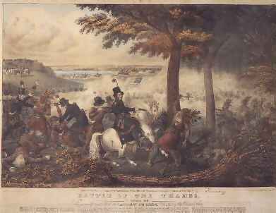
Battle of the
Thames, 5th October 1813
The original hand-coloured lithograph was printed some twenty years
after the event, and compresses time and geography to show the key elements of the Battle
of the Thames.
The central figures show Richard M. Johnson, colonel of a corps of
mounted Kentucky volunteers and in 1837 Vice-President of the United States, about to fire
on an Indian chief, purportedly the great Tecumseh who was killed in the battle.
Image:
9"X11"
Total Size with white border
and description 12"X14"
PNT-001
Special
Internet Price
24.50US (29.50CAN)
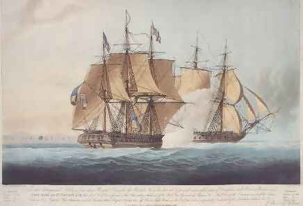
The Action between His Majesty's Ship Shannon
and the United States Frigate Chesapeake, off Boston Light House on the 1st of
June 1813
This is a very dramatic aquatint the HMS Shannon unleashes
a broadside the US Frigate Chesapeake, while in raking position.
It was
during this action the motto "Don't give up the ship" was uttered by the dying
American Officer Lawrence.
Image:
9"X11.5"
Total Size with white border
and description 12"X14"
PNT-002
Special
Internet Price
24.50US (29.50CAN)
Battle of Queenston Heights, 5th October 1812
This view of the famous 1812 battle is based on a sketch by James
Dennis, an officer of the 49th Regiment of Foot who took part in the battle, and shows the
American forces crossing the Niagara River form Lewiston under fire from the hastily
assembled Canadian militia and British regulars.
The Battle of Queenston is
remembered as the action where Major General Sir Isaac Brock fell.
Image:
9"X12"
Total Size with white border
and description 12"X14")
PNT-003 Special
Internet Price
24.50US (29.50CAN)
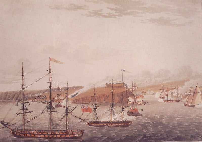
Attack on Fort Oswego, Lake Ontario, N. America, May
6th, 1814
Fort Oswego, an important American base at the eastern end of Lake
Ontario, was captured on 6 May 1814 by a force of British regulars, marines and seamen,
and Upper Canadian militia.
This work is based on a drawing by Lieutenant John
Hewett, a Royal Marines officer, who rushed the fort's flagstaff, climbed it under heavy
fire and ripped down the American flag.
All the ships are named in the bottom legent
of this print along with the regiments landing on shore.
Image:
9.5"X11.5"
Total Size with white
border and description 12"X14")
PNT-004
Special
Internet Price
24.50US (29.50CAN)
A View of Fort George, Upper Canada, from Old Fort
Niagara
This view of Fort George from the American side illustrates the
"strategic checkmating" along the Niagara River during the War of 1812. Fort
George, the military headquarters of Upper Canada, was built in 1796 to replace Fort
Niagara, then in the United States.
The fort was captured by an American force in
May 1813 and largely destroyed in December of that year on their withdrawal.
Image:
7.5"X12"
Total Size with white border
and description 12"X14")
PNT-005 Special
Internet Price
24.50US (29.50CAN)
A View of the Lake & Fort Erie, from Buffalo
Creek
Fort Erie was part of the chain of communications between Lakes
Erie and Ontario.
Seized by American forces in July 1814, Fort Erie was the centre
of several engagements during that year.
This view, in quieter times before the war,
shows its important harbour.
Image:
9"X11.5"
Total Size with white border
and description 12"X14")
PNT-006
Special
Internet Price
24.50US (29.50CAN)
Series Two: 5
Large Fort Plans & 1 Watercolour
Own the whole series for 95 US (99.50CAN)
Click Here for Image
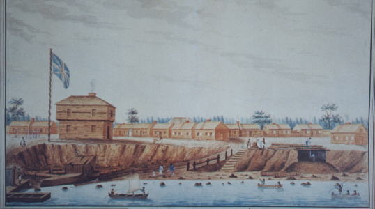
York Barracks, Lake Ontario, Upper Canada, Anno
Domini 1804
Begun by Lieutenant Governor John Graves Simcoe in 1793, Fort York
provided needed protection to the little capital of Upper Canada then forming.
During the American attacks of 27 April and 31 July 1813, the fort and government
buildings were destroyed.
Except for a few minor improvements, the defences at York
in 1813 had remained unchanged from this earlier view.
Image: 11"X18"
Total Size with white border and
description 16"X20") PNT-007 Special Internet
Price
24.50US (29.50CAN)
Click Here for Image
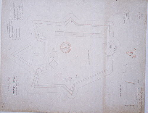
A Plan of the Fort at Point Henry in its present
state, May 1814
Overlooking the harbour and naval yard, Fort Henry was part of the
expanded defence works built at Kingston during the War of 1812.
Constructed of
timber and earth faced with stone, the fort was demolished in 1832 to make way for the
large stone citadel that stands today.
Image: 14"X 18"
Total Size with white border and
description 16"X20") PNT-008 Special Internet
Price
24.50US (29.50CAN)
Click Here for Image
Plan of the present state of Fort George, June
20th, 1814
Initially constructed in 1796 to replace Fort Niagara, Fort George
was largely destroyed during operations in 1813.
In 1814 efforts were undertaken to
reconstruct the fortifications; nevertheless, the site was of diminishing importance and
was finally abandoned in 1828.
Now fully restored, its invaders are U.S. and
Canadian tourists
Image: 14"X18"
Total Size with white border and
description 16"X20") PNT-009 Special Internet
Price
24.50US (29.50CAN)
Click Here for Image
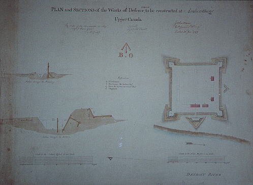
Plans and Sections of the Works of Defence to be
constructed at Amherstburg, Upper Canada 1799
The headquarters of the British Right Division during the War of
1812, Fort Amherstburg was little changed from this earlier plan.
Destroyed by the
retreating British and Canadian forces in September 1813, the site was then occupied by an
American force until July 1815.
Fort Malden was constructed on the ruins of the
first fort, and is today a National Historic Site.
Image: 11"X18"
Total Size with white border and
description 16"X20") PNT-010 Special Internet
Price
24.50US (29.50CAN)
Click Here for Image
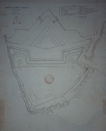
Sketch of Fort Niagara,in its presnt state, July
6th, 1814
One of the British forts relinquished to the United States in 1796,
Fort Niagara was captured by British and Canadian forces in December 1813.
Fort
Niagara, with minor improvements, was retained for the balance of the war.
With the
signing of the Treaty of Ghent, the fort again reverted to the United States.
Fort
Niagara is today a New York State Historic Site operated under licence by the Old Fort
Niagara Association.
Image: 13" X 18"
Total Size with white border and
description 16"X20") PNT-011 Special Internet
Price
24.50US (29.50CAN)
IMAGE COMING SOON
Plan of the present state of the fort erecting at
Point Mississauga, at the entrance of the Niagara River, 1814
Fort Mississauga was begun in the spring of 1814 as part of the
increased defences at Niagara, although it was never more than an incomplete field work
during the war.
Its central tower was partially constructed from the brick remains
of Niagara town buildings burned by the retreating Americans in December 1813.
The
tower is today an integral part of a golf course.
Image: 11"X18"
Total Size with white border and
description 16"X20") PNT-012 Special Internet
Price
24.50US (29.50CAN)
Series Three: 3
Large Naval Plans & 1 River Battle Map
Own the whole series for 89 US (95 CAN)
Click Here for Image
Plan of Sackets Harbor, c. 1815
Sacket's Harbor was the most important American naval yard on Lake
Ontario.
In May 1813 an unsuccessful attack was launched against the place in an
attempt to destroy the shipbuilding facilities.
This manuscipt plan shows the
fortifications and ships in the harbour, and fom several references was probably prepared
during a number of secret reconnaissances immediately after the war.
Image: 9.75"X17.5"
Total Size with white border and
description 16"X20") PNT-013 Special Internet
Price
24.50US (29.50CAN)
Click Here for Image
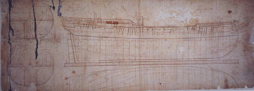
Plan of HM Frigate Princess Charlotte,
1813
Launched at Kingston in April 1814, the Princess Charlotte
was a 44-gun frigate typical of the larger class of vessels constructed by both sides
during the War of 1812.
She took part in the attack on Fort Oswego in May 1814 and
in the blockade of Sackets Harbor.
Renamed Burlington, she was laid up
after the war and was "supposed taken to pieces: in January 1833.
Image: 6.75"X18"
Total Size with white border and
description 16"X20") PNT-014 Special Internet
Price
24.50US (29.50CAN)
Click Here for Image
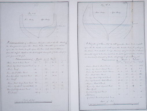
Ships' dimensions and draughts of a Royal Navy Schooner
Frigate of 22 guns and of a Frigate of 32 guns, 1813.
To maintain British naval superiority on the Great Lakes, it was
proposed to build ships in Canada from frames transported from England.
The frigate Psyche
was launched at Kingston in December 1814 from frames constructed in Britain and hauled up
the St. Lawrence by bateaux.
With their experience and knowledge, master
shipbuilders would produce the vessels from simple lines and dimensions like those
reproduced.
Image: 11"X18"
Total Size with white border and
description 16"X20" PNT-015 Special Internet
Price
24.50US (29.50CAN)
Click Here for Image
Two 1812 images on one print!
1. Part of the River Thames, Upper Canada, 9
August 1814
Following the loss of the naval squadron on Lake Erie in September
1813, the British Right Division was forced to retreat from Amherstburg up the Thames
River.
Caught by the pursuing American army nar the village of Moraviantown, the
largest part of the British and Canadian force was captured in the ensuing battle and the
Shawnee chief Tecumseh killed.
This plan marks the general line of retreat and
location of the American advance.
2. Sketch of part of the River Chateauguay, 1814
In the autumn of 1813 an American force of 4,000 troops advanced up
the Chateauguay River as part of a two-pronged attack on Montreal.
Met by a small
force of Canadian Fencibles, Voltigeurs and militia under led by Lt. Col. Charles de
Salaberry, the Americans were forced to withdraw, and Montreal was saved.
This plan
was prepared from a sketch by de Salaberry and shows the skillful positioning of the
defending Canadian force.
2 images each measuring 6"X18"
Total Size with
white border and description 16"X20" PNT-016 Special
Internet Price
24.50US (29.50CAN)

Click Here
for FAX Order Form

wa
Contacting
us
Copyright:
Unless otherwise noted, all information, images, data contained within this website is
protected by copyright under international law.
Any unauthorized use of material
contained here is strictly forbidden.
All rights reserved.
Access Heritage Inc (formerly The Discriminating General) is in no way to be held accountable for the use of any content on this website.
See
Conditions of Use.
| 